|
Getting to the drop zone is easy! Folow these simple directions and take a look at the map below:
Take I-94 East (runs north-ish out of Detroit)
Take Exit 248 (26 Mile Road), you will see signs for and Airport.
Go East on 26 Mile Road for about 8 miles.
Airport will be on the right (south) side of the road.
Important: See the parking instructions below!
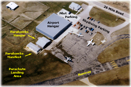
 Parking Instructions
When you arrive at the airport, we ask that you park in the areas indicated on the map of the airport grounds,
below. Aircraft owners and pilots are the only ones that should park on the cement parking area located
between the large blue hangar and the white house. The skydivers and students should park on the asphalt (blacktop)
portions of the parking lot. Please notify all members of your group of this request.
Parahawks reconnaissance photo.

|
